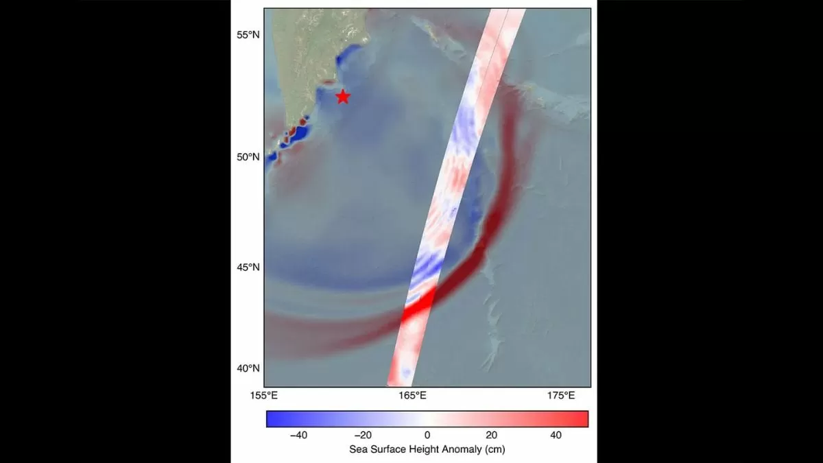
On July 30, 2025, the world witnessed a remarkable event, captured by the NASA-CNES SWOT satellite. The satellite captured the leading edge of a tsunami wave in the Pacific Ocean, triggered by a powerful 8.8 magnitude earthquake near Russia’s Kamchatka Peninsula. This groundbreaking moment not only showcased the advanced technology of the SWOT satellite but also provided crucial information about the tsunami that could potentially save countless lives in the future.
The SWOT (Surface Water and Ocean Topography) satellite is a joint mission between NASA and the French space agency, CNES. It is equipped with state-of-the-art radar technology that can measure the height, profile, and speed of ocean waves with unprecedented accuracy. This makes it an invaluable tool in monitoring and predicting natural disasters such as tsunamis.
The 8.8 magnitude earthquake that occurred near the Kamchatka Peninsula was one of the strongest earthquakes in recent history. It caused significant damage to the surrounding areas and triggered a tsunami warning across the Pacific. The SWOT satellite, which was orbiting the Earth at an altitude of 830 miles, was able to capture the tsunami wave just 70 minutes after the quake.
The data collected by the SWOT satellite showed that the wave measured 1.5 feet in open water, but it could grow to a staggering 30 feet when it reached the shore. This information was crucial for coastal communities as it gave them a better understanding of the potential impact of the tsunami. With this knowledge, they were able to evacuate people from the affected areas and minimize the loss of life.
The SWOT satellite’s advanced radar technology also mapped the wave’s height, profile, and speed, providing scientists with valuable data to study and understand tsunamis better. This information can help in developing more accurate prediction models and early warning systems, which can save lives in the event of future tsunamis.
Apart from its role in disaster management, the SWOT satellite also plays a crucial role in monitoring the Earth’s water bodies. It can measure the height and shape of oceans, lakes, and rivers, providing scientists with a better understanding of the Earth’s water cycle. This data is essential for studying climate change and its impact on the planet’s water resources.
The successful capture of the tsunami wave by the SWOT satellite is a testament to the collaboration between NASA and CNES. The two agencies have been working together for over a decade to develop and launch this groundbreaking satellite. The SWOT mission is a prime example of how international cooperation and the use of advanced technology can lead to significant scientific advancements.
The SWOT satellite is just one of the many projects that NASA and CNES are working on together. Their partnership has resulted in numerous successful missions, including the Ocean Surface Topography Mission (OSTM) and the Jason-3 satellite, which have provided invaluable data on ocean currents and sea level rise.
The successful capture of the tsunami wave by the SWOT satellite has not only showcased the capabilities of this advanced technology but has also highlighted the importance of investing in scientific research and development. The data collected by the SWOT satellite will not only help in disaster management but also in understanding our planet better and making informed decisions for its future.
In conclusion, the NASA-CNES SWOT satellite has once again proven its worth by capturing the leading edge of a tsunami wave in the Pacific Ocean. Its advanced radar technology has provided crucial information about the wave, which can help in minimizing the loss of life in the event of future tsunamis. This groundbreaking moment is a testament to the power of international collaboration and the use of advanced technology in making our world a safer place.


